
The World-Leading Earth Observation Solutions Provider
팝업레이어 알림

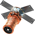
SpaceEye-T
30cm Ultra-High Resolution Commercial Satellite Imagery for Earth Observation
SpaceEye-T is the first commercial satellite developed by Satrec Initiative Group with 100% of own technology and capital.
It will be launched in 2024, and SI Imaging Services will officially supply its imagery data.
With the launch of SpaceEye-T, we will take a step forward in realizing our mission of fair access and value to space.
VIEW MORE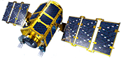
KOMPSAT
Electro Optical
KOMPSAT-2, 3, 3A
Korean Multipurpose Satellite (KOMPSAT) was developed by the Korea Aerospace Research Institute (KARI) to secure domestic satellite development technology and public demand for satellite imagery, and SI Imaging Services is in charge of commercial supply worldwide.
KOMPSAT-2, 3, and 3A are optical satellites with 0.4M to 1M resolution, and KOMPSAT-7 and 7A with 0.3M resolution are scheduled to be launched in 2024.
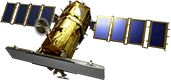
KOMPSAT
SAR
KOMPSAT-5
KOMPSAT-5 is a SAR (Synthetic Aperture Radar) satellite which provides clear radar images with a resolution of up to 0.85M. Since it is not affected by light, it is possible to observe the Earth day and night, all-weather.
KOMPSAT-6 is a 0.5M radar satellite and is scheduled to be launched in 2024.
VIEW MORE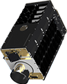
GHGSat
Methane Tracking Satellite
Measuring Methane Emissions on Facility Basis
Through a partnership with Canada's GHGSat, a company specializing in greenhouse gas monitoring, SI Imaging Services supplies methane emission data to domestic and Asian customers.
GHGSat's satellites provide 100 times better spatial resolution than other greenhouse gas monitoring satellites, enabling accurate detection of methane emissions from specific areas of oil and gas facilities.
VIEW MOREAdvantages of Our Satellite Imagery
-
Specialized in
VHR Satellite Imagery
Provides imagery
up to 0.4M resolution -
Both Optical and
SAR Data Available
Owns sales rights for
both optical and
SAR data of KOMPSAT -
Guaranteed and
Stable Supply of Data
Preparing for SpaceEye-T and
the next KOMPSAT services -
Sales Networks Built
over 10 Years
Multinational sales networks
established through
worldwide partners
Contact
Send us all your inquiries and we will give you prompt feedback.
ADDRESS : 169-84, Gwahak-ro, Yuseong-gu, Daejeon, KoreaTEL : 042-341-0401
Copyright 2022 SIIS. All rights reserved. Admin